

Survival: Orienteering, basic star navigation
Some thoughts on navigation in the old days and practical tips for staying on course while outdoors during the night.
One of the great joys of the Norwegian countryside during winter is the absence of light pollution. This gives a crisp view of the starlit firmament and the opportunity to view the Northern Light clearly. It inspired writers and painters for its romantic potential.
In the times of global position systems (GPS, Galileo and Glonass) on almost all electronic devices from phones to watches and an ever evolving light emitting diode (LED) technology in headlamps, people nowadays stumble merely blind through the night. Blind in the regards of being totally dependent on the technology that has revolutionized the last decades. No, I am not talking about social media.
The knowledge of safely traveling through the night with only your eyes and starlight as help has become mostly forgotten. Many people become outright uncomfortable with only the thought of outdoor activities off the beaten track during these hours without a minimum of _ _ _ (enter your lumens here) torch, battery backup and a power bank for your iPhone. And it might be completely dark for up to 22 hours in the Northern parts of Norway. This sets real limitations.
As a big fan of military history, I get impressed by the level of sophistication and training necessary to obtain a god position in the times before GPS. It is safe to assume that the German submarine warfare during World War II perfected terrestrial navigation to the utmost, obtaining a position fix with the help of stars. There is one story of a German U-boat that stayed submerged for 66 days to avoid capture at the end of the war and navigated during this time safely from Norway to Spain, and then on through the whole Atlantic Ocean to Argentina. Only getting up to periscope level to charge its batteries with the Diesel engine and to obtain a position fix.
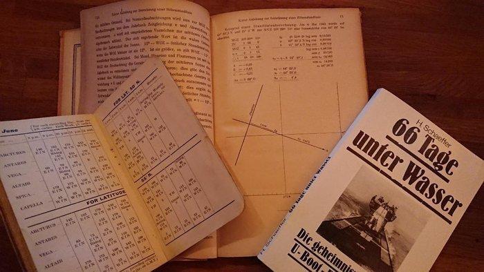
I am very thankful for the possibilities that my tiny GPS watch gives me. Yes, I also use the joys of modern electronics, because it is about 100 times more precise than the navigator on the named “U-Boot”. I also get the readout in the blink of an eye, not after 20 minutes – the time it would take to finish all the advanced mathematical calculations like spherical trigonometry and even stochastic necessary to predict position, course and speed. A knowledge called “art” in the publication of a naval war manual from the 1940s, better known as dead reckoning, which would make for another interesting article.
If we look farther back in time we can learn that the great explorers like the brutal Vikings, Norwegian ancestors, and discoverers like Christopher Columbus were able to reach their goals without GPS, even though they might end up at another continent than anticipated, which was rather an error in world view than navigational miscalculations. They didn’t have the refined technological instruments, maps, sextant, and most importantly a precise watch (called chronometer) which is mandatory for obtaining the longitude of a position. More “recent” adventurers and explorers like the Scott and Amundsen used these instruments like many for hundreds of years before them to pinpoint a location, like the one of the South Pole.
If you lose me, my point is that we can orient ourselves with very simple measures, which can be a survival skill if need be. At the least it lets us appreciate more what technology does for us today.
Have you ever wondered if there is a greater meaning behind the Zodiac signs and constellations, outlining patterns and drawings of people and animals you might have hear of? Well not in predicting your future love life, we are talking about astronomy, not astrology. It is actually a smart way to point out fix stars without paper: Stars that aid in navigating. This knowledge was handed down from generation to generation. What smart way to teach children! I wonder how they managed to actually get these skills across without having them sit still for hours on a school bench with an iPad. Well, I digress by attacking our school system. Not my intent, sorry.
A very useful app that I can truly recommend for finding stars, planets and constellations is Star Chart. It gives you more information than you will ever need, doesn’t need a mobile connection and is free of charge. It is eye safe (dark red screen) so you won’t loose your night vision and is augmented as you move it over the sky. It’ll transform that iPad finally into a useful tool. I really do love iPads.
In the following part I would like to present you some of the celestial bodies and their useful application. I only focus on the Northern hemisphere for now:
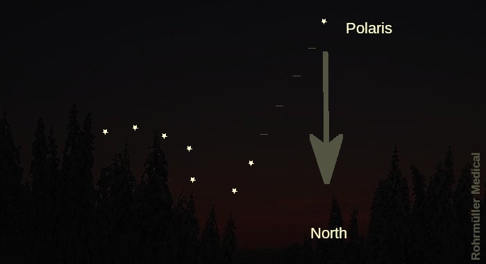
Big Dipper
The seven bright stars, part of the Ursa Mayor. Find it and extend it’s rear axis 5 times towards the “top” of the wagon. It leads you to the polar star, which always appears to be right above the North Pole. Draw a vertical line to the horizon and you have the direction North. Approximate the angle from the horizon to the star and you have the latitude. From my position right now in Norway, it is about 60 degrees. This means I am 60 degrees North (90 degrees would be the North Pole). Knowing that 1 degree equals 60 nautical miles, I am 1800 NM from the North Pole (90degrees minus 60 degrees = 30 degrees. Times 60 and you have the distance). I also know that I am 3600 NM from the equator.
Cassiopeia
Looks like a big letter “W”, or “M”, dependent on the view. Extend the middle axis towards the tip and it will lead you to the polar star. 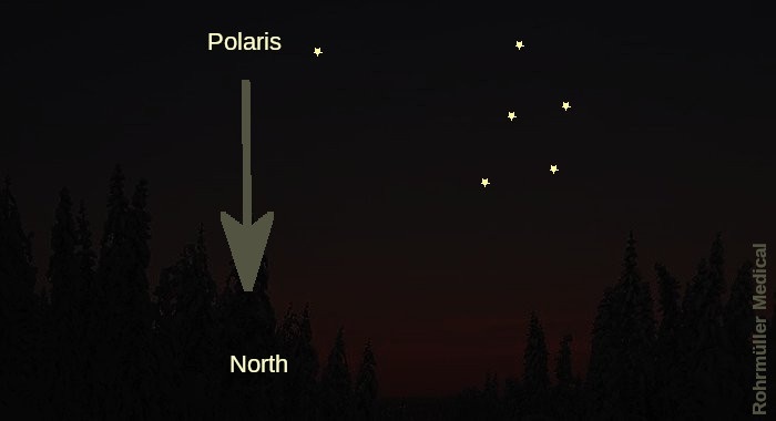
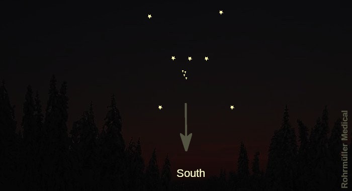
Orion
Find Orion’s belt with the prominent three stars in a line, and the “sword” of the Saggitarius hanging from this belt. This is actually no star but a big cluster, the Orion nebula. For a rough bearing, the belt will be pointing East-West when it is at it’s highest, and the sword will point down, towards South.
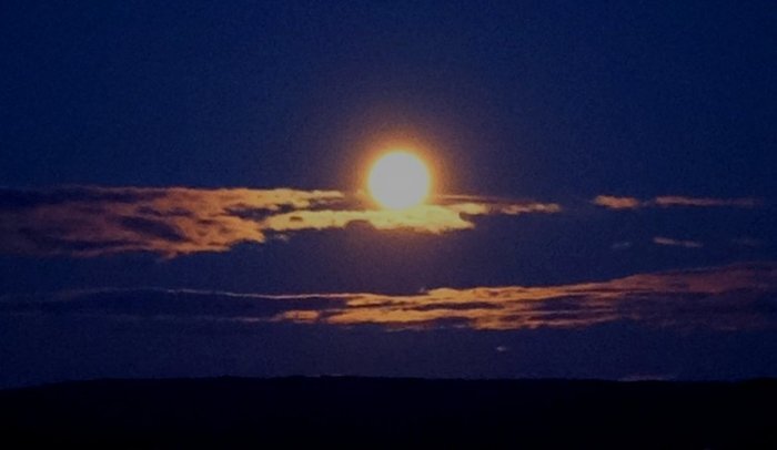
Planet Venus
Visible as a bright “star” due EAST just before sunrise and WEST shortly after sunset. Hence its name morning star (no, not the Chicago based investment research firm) and evening star. 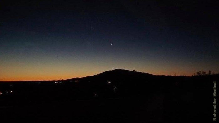
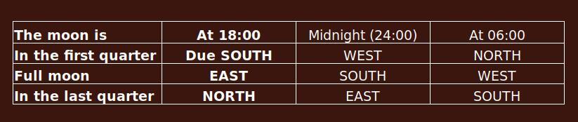
Also our moon can be used in finding your direction.
I found this rather peculiar navigation “trick” in an old WW2 manual and wasn’t aware of it, as most “modern” emergency navigation literature says that the moon isn’t reliable for navigation. And it seems so, most of the time, when you see the moon, it is all over the place, makes sense as it isn’t a very far object and “only” orbits around our world. The manual suggests to memorize the following table by visualizing the apparent movement of the moon from North via East to South (similar to the sun) and the first two vertical columns. Then it’ll be easy to acquire the approximate moon position for each hour. Here we go:

Using the weather side of trees is an unreliable method, independent of at day or night. It is totally dependent on micro climate and cannot be used for navigational purposes.
The best and most reliable aid in finding cardinal directions is still the compass.
All this makes especially sense, if you have a general idea in which direction you want to go.
So I encourage you to get out there, next time you drive to your hut, cross country skiing or walking around the block. Turn off your light, wait a couple of minutes and take in the beauty. Be it with your loved one, your children or all by yourself. With a little training you will be able to point out some of the constellations. It gives great satisfaction.
All comments are moderated before being published. Your email will not be visible